Today, the person in whose location the gadgets will never get lost. It will help out Google Maps or Yandex.Maps. Thanks to technology, we are confident that applications are kept up to date in real time. But it was not always so.
The map is one of the most outstanding inventions of mankind. She has always been more than just a navigation tool. Throughout history, people followed the maps, created and constantly updated them to pave their way around the world. Maps were used to illustrate discoveries and convey new ideas.
The earliest maps were discovered by archaeologists among the cave paintings. Their gradual development led to the era of great geographical discoveries. In the 16th century, they were a mixture of fantasy, real knowledge and assumptions. Cartography has become a real art. Antique cards are highly regarded by collectors today.
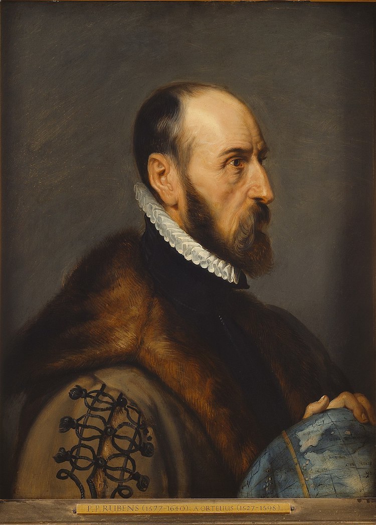
Abraham Ortelius is a key figure in the history of cartography. He is known as the inventor of the atlas book containing several maps under one cover.
Ortelius was born in Antwerp, Belgium, on April 14, 1527, at the height of the era of humanism. At this time, in Western Europe, there was a revival in the study of classical antiquity, history, the Greek language and philosophy. The 16th century was a time of research, revolutionary inventions, and a new world view.
Ortelia was fascinated by new discoveries and travels. He began to collect books, prints, paintings, wall maps and coins from all over Europe. During one of his trips to Poitiers, France, Ortelius met the cartographer Gerard Mercator, who inspired him to draw up maps on his own. The career of the master began in 1547 with the post of colorist cartographer in the guild of St. Luke in Antwerp. He then continued with Plantin in 1587. The first maps of Ortelius were large wall maps of the world, Egypt, the Holy Land, Asia, Spain and the Roman Empire – and since then it has been hooked.
The world’s first atlas
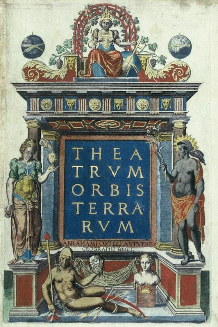
The first atlas of Ortelius was called Theatrum Orbis Terrarum (Spectacle of the circle of the earth). First printed in 1570, it contained a collection of 53 cards, made in the same style and size, on copper plates and located on continents and regions. There were almost no maps in the atlas created by Ortelius himself, but he admired the maps of other masters, on each of them a source was indicated.
Theatrum Orbis Terrarum was so successful that it had to be reprinted 4 times in the first year of publication. In the period from 1570 to 1612, the atlas survived 42 reprints in 7 languages, including Latin, English, German, Flemish, French, Spanish, and Italian.
Ortelia World Map
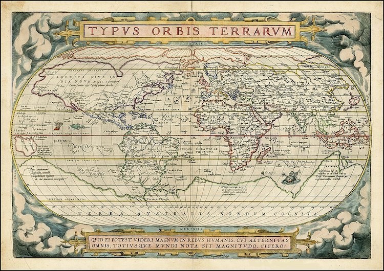
Although the Atlas did not contain many maps of Ortelius, it represented the most famous – Typus Orbis Terrarum (1570). Perhaps one of the most iconic maps ever created, it covers the whole world from pole to pole, revealing the shape and size of continents based on the knowledge of the time.
Ortelius designed the map in accordance with previous maps of the world from other cartographers, but he also added new information based on his own guesses and estimates. At the time of the map, most of North America had not yet been explored. There is no Mississippi River and Great Lakes on it.
Many objects on the map were based on new information from researchers. For example, the shores of Southeast Asia and the Indian archipelago appeared as a result of Portuguese travels, and knowledge of the Asian world was based on travel reports from Marco Polo from the 13th century.
A map of Ortelia was created before the official discovery of Australia, but it has an image of the earth named Terra Australis Nondum Cognita (Unknown Southern Land). This suggests that researchers already assumed its existence, but have not yet fully proved it. The map also illustrates Papua New Guinea, almost annexed to the southern lands, with a Latin text explaining: “New Guinea, recently discovered. It is not known whether it is an island or part of the Southern continent. ”
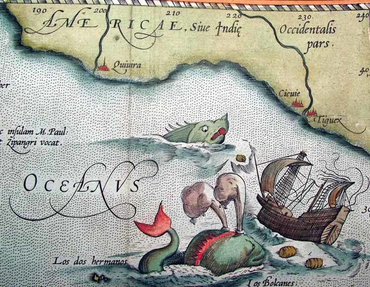
Mythical Sea Monsters
Perhaps this tradition was influenced by Greco-Roman images of mythological animals. However, Ortelius was one of the last cartographers who agreed to include them in his cards. The Atlas of Theatrum Orbis Terrarum was published at a time when cartographers began to prefer science and accuracy instead of aesthetics.


Customer
Can you be more specific about the content of your article? After reading it, I still have some doubts. Hope you can help me. https://www.binance.com/zh-CN/register?ref=WFZUU6SI
Customer
Can you be more specific about the content of your article? After reading it, I still have some doubts. Hope you can help me. https://accounts.binance.info/register-person?ref=IXBIAFVY
Customer
I don’t think the title of your article matches the content lol. Just kidding, mainly because I had some doubts after reading the article. https://accounts.binance.com/id/register?ref=UM6SMJM3
Customer
dubuque iowa casino
References:
https://al-nasr-sports-club.org/user/regwanondv
Customer
Thanks for sharing. I read many of your blog posts, cool, your blog is very good.
Customer
Thanks for sharing. I read many of your blog posts, cool, your blog is very good.
Customer
Many people now turn to pure steroid alternatives and SARMs (Selective Androgen Receptor Modulators) that offer comparable outcomes with fewer dangers. Cognitive behavioral therapy (CBT) approaches have proven promise in addressing some of the psychological effects of steroid use. CBT might help reframe distorted ideas about physique image, present tools for managing mood swings, and assist in creating healthier coping mechanisms. It’s like giving your thoughts a toolbox to repair the psychological leaks that steroids would possibly spring. Talking of despair, it’s a typical unwelcome guest within the steroid user’s psyche.
Treatment must be withheld in males with a palpable prostate nodule or prostate-specific antigen of more than 4 ng/mL and in patients at excessive risk of prostate malignancy with prostate-specific antigen of greater than 3 ng/mL. Some combine this with corticosteroids, which treat inflammation but don’t build muscle. Some folks can turn out to be used to the feeling of energy or endurance that steroids give them and turn out to be dangerously addicted. Lengthy time period, unregulated use of AASs can have an effect on some of the same brain pathways and chemicals that are affected by other drugs, such as opiates. Non-medical use of steroids can involve portions from 10 to 100 occasions the amount used for medical purposes.
I cannot find a smoking gun for when that occurred, but the usage doubtless emerged between the early Nineteen Eighties and the mid Nineties. From this word, we also have the expression ‘juiced up’, which implies that one thing has been full of gasoline, or running at most energy. Persons taking steroids are frequently described as ‘juiced up’, so it is not stunning that ‘juice’ has turn into slang for the steroids themselves. The watery or liquid a half of greens or fruits, which may be expressed or extracted; generally containing the characteristic flavour and other properties. Stack Exchange network consists of 183 Q&A communities together with Stack Overflow, the most important, most trusted online neighborhood for developers to be taught, share their data, and build their careers. Additionally, any achievements the athlete made while on steroids could be questioned. Individuals might say, “They didn’t actually need to be on the All-Star team” or “They did not earn that trophy.”
Despite being banned in aggressive sports, abuse persists, particularly among athletes and adolescents influenced by societal pressures and unrealistic body requirements. You might see ads for these on the Web or at the again of sports activities or body constructing magazines. Kids mustn’t take any steroid complement, even these nonetheless being sold. Anabolic steroid medicines embody testosterone cypionate (such as Depo-testosterone) and testosterone undecylenate (such as Andriol). Illegal anabolic steroids are those who people get without a doctor’s prescription.
Cleveland Clinic’s main care providers provide lifelong medical care. From sinus infections and high blood pressure to preventive screening, we’re right here for you. Withdrawal signs vary with each patient, and the healthcare professional may must prescribe short courses of medicines to assist with complications, muscle aches, and insomnia. Melancholy and suicidal thoughts could occur when one stops taking steroids, and this potential should be monitored carefully. They are legal when prescribed for medical functions but illegal for non-medical use in many jurisdictions. Your physician might ask questions about your health actions and what kinds of dietary dietary supplements and different substances you utilize. The extent of those changes is fairly small, but DiPasquale is firm on his stance that saturated fat are important for optimum hormone production.
Importantly, 37% of the topics had signs of irregular gonadal perform at baseline of which 95% had a history of AAS use. This might be defined by incomplete recovery of the HPGA due to recent AAS use or prolonged or persistent hypogonadism from previous use. A case-control research also suggests that AAS use results in a persistent small reduction in testosterone ranges (177). Nevertheless, latest or current unreported AAS use, reverse causality and other components inherent to a case-control research design make it tough to ascertain a true cause-and-effect relationship. Regardless, persistent AAS-induced hypogonadism has been reported within the literature in several cases (65, 178).
Testosterone, and its estrogenic metabolite estradiol, exert adverse feedback on the hypothalamus and pituitary to suppress their very own synthesis (173, 174). Estradiol particularly is awfully potent at suppressing gonadotropin secretion as, on a molar basis, it is estimated to be 200-fold stronger than testosterone in doing so (175). Consequently, exogenously administered AAS may also exert adverse feedback, thereby suppressing testicular testosterone production and spermatogenesis.
The opposed effects of AAS use rely upon the product, the person’s age and intercourse, how a lot they use, and for a way lengthy. The solely means to make use of steroids legally is to have a prescription for them. Excessive doses of oral AAS compounds can cause liver harm.[5] Peliosis hepatis has been more and more recognised with the utilization of AAS. Since the discovery and synthesis of testosterone within the Nineteen Thirties, AAS have been utilized by physicians for many functions, with various degrees of success. These can broadly be grouped into anabolic, androgenic, and different uses.
References:
https://pedselite.com/comprar-clenbuterol-en-linea-guia-completa-para-comprar-clen/43217/
Customer
arnold steroids
References:
https://naijasingles.net/@latriceolsen53
Customer
cutting stack bodybuilding
References:
https://gitea.fuluzhanggui.com:99/jeffereyreece
Customer
May I simply just say what a relief to uncover someone that really understands what they’re talking about on the net.
You certainly realize how to bring an issue to light and make it important.
More and more people ought to look at this and understand this side
of your story. I can’t believe you aren’t more popular since you most certainly possess the
gift.
Customer
Your point of view caught my eye and was very interesting. Thanks. I have a question for you. https://www.binance.info/cs/register?ref=S5H7X3LP
Customer
Can you be more specific about the content of your article? After reading it, I still have some doubts. Hope you can help me.
Customer
Thanks for sharing. I read many of your blog posts, cool, your blog is very good.
Customer
Thanks for sharing. I read many of your blog posts, cool, your blog is very good. binance
Customer
Can you be more specific about the content of your article? After reading it, I still have some doubts. Hope you can help me.
Customer
how to take dianabol cycle
References:
dianabol primobolan cycle [https://telegra.ph/Primobolan-Cycle-Guide-Maximizing-Outcomes-With-Correct-Dosage-08-19]
Customer
testosterone and dianabol cycle
References:
test dianabol cycle (http://autoexotic.lv/user/snailquartz7/)
Customer
what is considered a high roller in vegas
References:
https://list.ly/steve-robinsos
Customer
game of spades
References:
high roller online casino download [https://intensedebate.com/people/poetrod66]
Customer
Asking questions are really pleasant thing if you are not understanding anything totally, but this post provides nice understanding yet.
Customer
Thank you for your sharing. I am worried that I lack creative ideas. It is your article that makes me full of hope. Thank you. But, I have a question, can you help me?
Customer
Can you be more specific about the content of your article? After reading it, I still have some doubts. Hope you can help me.
Customer
Comment
Customer
Can you be more specific about the content of your article? After reading it, I still have some doubts. Hope you can help me.
Customer
70918248
References:
https://embraceyourpowercoaching.com/life-is-calling-are-you-ready-to-answer
Customer
70918248
References:
none (http://alasdelsur.com/2022/07/01/how-to-travel-with-paper-map/)
Customer
70918248
References:
https://blog.c-mart.in/posts/about/create-comment
Customer
70918248
References:
none – https://coolcoder.org/2024/06/15/the-future-of-health-it-digital-healthcare/ –
Customer
70918248
References:
none (https://alltozone.com/hello-world/)
Customer
70918248
References:
https://bakuhitfm.az/2020/11/04/electronic-music-history-and-todays-best-modern-proponents/
Customer
70918248
References:
none (http://ascrolite.com/component/k2/item/1%5D???z?[.html)
Customer
70918248
References:
https://old.newcroplive.com/2017/11/28/six-robots-that-are-changing-the-food-service-industry/
Customer
70918248
References:
https://picpiggy.com/pretty-box-bakery-game-makeup-kit/
Customer
70918248
References:
https://blog.ginsainformatica.es/digital-marketing-explained-2/
Customer
70918248
References:
steroids side effects For men (https://kaospolosaneka.com/mix-match-kaos-polos-ala-raditya-dika/)
Customer
70918248
References:
testosterone steroids for sale (https://pulsezenx.com/a-complete-guide-to-egypt-visa-for-swedish-citizens-essential-information-and-requirements/)
Customer
70918248
References:
https://sleepfreshup.com/best-sofa-manufacturer-in-kirti-nagar/
Customer
70918248
References:
steroids price list; https://bsbdiesel.com.br/startup-lessons-stories-of-success-and-failure/,
Customer
70918248
References:
steroid diet plan bulking (https://recoverysolutions.us/facility/test-2/)
Customer
70918248
References:
https://utshonews.com/?p=352
Customer
70918248
References:
how dangerous are steroids (https://myrcludex.info/harnessing-the-power-of-social-media-for-business-growth/)
Customer
70918248
References:
pharmaceutical grade steroids for sale – https://771xeon.ru/lenovo/ –
Customer
70918248
References:
best steroid stack For mass (https://sovereignag.com/maximizing-solar-energy-efficiency-tips-for-optimal-performance/)
Customer
70918248
References:
androgenic steroid – https://www.onoranzefunebricolletta.it/home/how-is-the-funeral-process/ –
Customer
Thank you for your sharing. I am worried that I lack creative ideas. It is your article that makes me full of hope. Thank you. But, I have a question, can you help me?
Customer
70918248
References:
Steroids bodybuilding tablets (https://jpabs.org/800/600/http/mongocco.sakura.ne.jp/bbs/index.cgi%3Fcommand=read_message&%3Ewww.ksmro.co.kr/bbs/index.cgi?command=viewres&target=251167195)
Customer
70918248
References:
female Bodybuilder steroids (https://lakestarrsolutionsllc.com/page20.php?messagePage=9157)
Customer
Thanks for sharing. I read many of your blog posts, cool, your blog is very good.
Customer
Your point of view caught my eye and was very interesting. Thanks. I have a question for you.
Customer
70918248
References:
0ahukewjro_2u–_mahv9fjqihw1ccukq_auidcga|anabolic steroids|acybgnqivwvdk_gu8guso6hssvaojmb0yg:***, https://www.webwiki.fr/www.instapaper.com/p/16322121,